GIS Mapping
The Great Lakes RCAP Geographic Information System (GIS) Team is a true cooperative in that we work alongside communities to achieve goals related to the collection, mapping and maintenance of utility assets. We believe that the most sustainable product leverages the expertise of both utility personnel and our dedicated GIS staff. Recognizing that communities are the owners of their data, co-op membership includes support and training to empower communities to utilize their data to the maximum extent possible.
Cooperative Services
Since 2011, the GIS Coop has been providing GIS data hosting and maintenance services throughout Ohio. In addition to five full-time GIS professionals, we utilize software, high-accuracy GPS units, wide format scanners and printers and IT support to deliver comprehensive GIS and mapping services. The cooperative format allows for reduced costs for each community, while granting access to expertise. Member fees are proportionate based on the number of active water and sewer customers, and total population.
Coop services include:
- GIS data hosting
- Web and mobile applications
- Digital field inspections
- Maintain, edit and add data
- Post-construction Updates
- Site visits and training
- On-demand map printing and reports
- Scanning of maps, plans, as-builts
- Loaner GPS units (no-cost)
- Support for Asset Management Inventories
- GIS database designed to
support Asset Management
Fee for Service
Our approach differs from private consulting firms and other non-profits in that we partner with utilities in completing a data collection and mapping project. We have learned from experience that while as-builts and other reference documents can augment data collection and mapping, it truly is the combination of knowledge of local staff with our mapping expertise and equipment that leads to most accurate representation of a system.
And, ultimately this accuracy is going to provide the greatest benefit(s) long-term in the following ways:
- Increases efficiency in day-to-day operations
and in the field - Enhances project planning
- Supports asset management through
a comprehensive inventory - Geodatabase design which supports
asset management activities
Asset Management and GIS
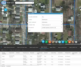
GIS is an integral component of an asset management program that inventories all system assets. GLRCAP supports systems by helping them maintain up-to-date inventories and maps, and by providing customized web and mobile applications to help utility staff find and update information about their assets.
GLRCAP can support two-way integration with many third-party asset management software programs. GLRCAP is also a leading organization providing technical assistance and training for the completion of Asset Management plans for both water and wastewater.
Mobile GIS Apps
We provide co-op communities with web and mobile applications for viewing and interacting with their data. We recognize that some communities may not be at a point to purchase additional software for asset management purposes, and have designed and implemented a database to address the asset management needs of small utilities.
Additional fields and related tables have been added to accommodate requirements related to the inventory, condition assessment, preventive maintenance and estimation of risk of failure of assets, among others. Through our applications, communities have the ability to update attributes related to each asset, and take advantage of web app tools such as filtering and mapping to support reporting requirements.